Daly Resources is exploring for copper and zinc in the world-class McArthur River and Georgina Basin regions of the Northern Territory, Australia.
ABOUT DALY RESOURCES
Daly Resources is a private Australian exploration company exploring for copper and zinc in the world-class McArthur River and Georgina Basin regions of the Northern Territory, Australia.
Daly’s team boasts over 40 years of combined experience in the Northern Territory in exploration geology across various mineral systems. The company has in-depth understanding of exploration methodologies, operational regime, costs, discovery risks and development thresholds in remote NT. They have on-going practical experience in all facets of land access in remote Australia, including access negotiations with stakeholder groups (Aboriginal, Land Councils, Pastoral), Aboriginal heritage, environmental, regulatory regime and OHSE.
PROJECT LOCATIONS
Daly Resources
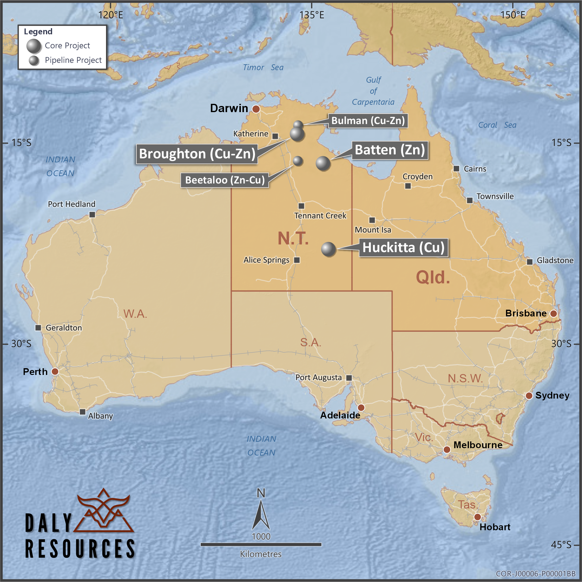
Batten Project
McArthur Basin
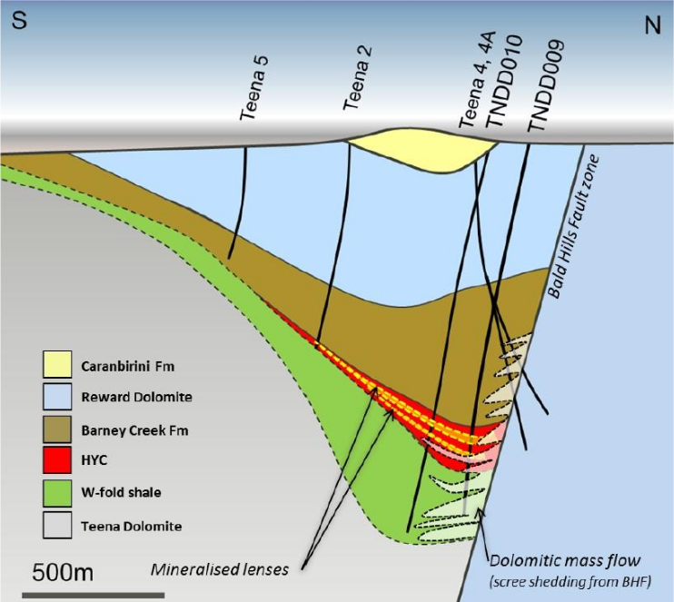
Teena Analogue
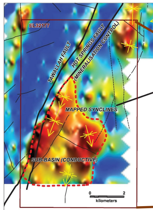
Untested conductor
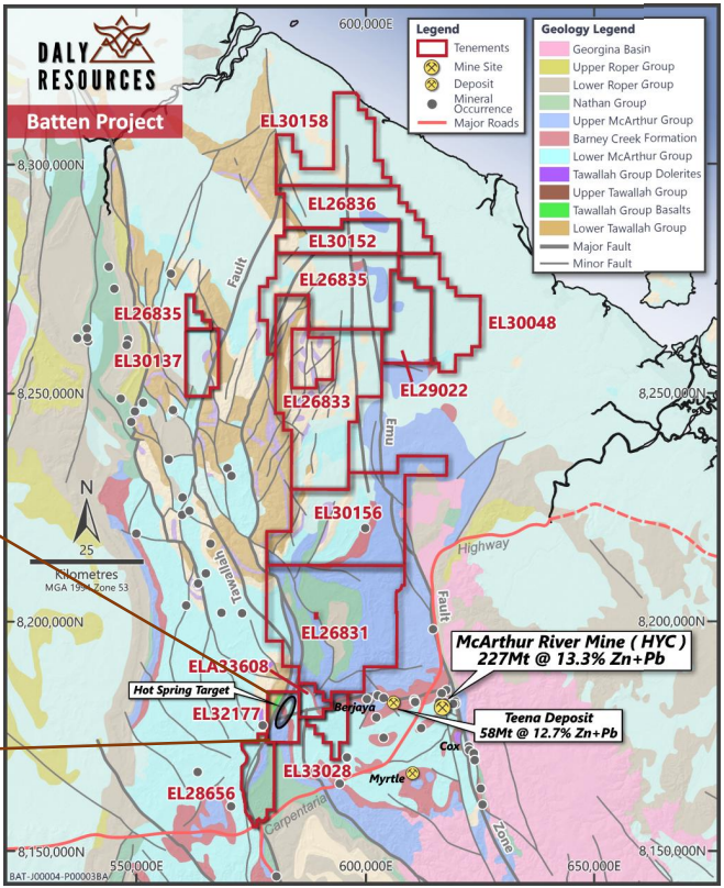
Dominant ground position in the premier SEDEX Zn province in Australia
Target commodity & analogue
Zinc – stratiform sediment-hosted exhalative (SEDEX)
HYC Deposit / McArthur River Mine (227 Mt @ 9.2% Zn, 4.1% Pb, 41 g/t Ag & 0.2% Cu) Teena Deposit (58Mt @ 11.1% Zn & 1.6% Pb)
Overview
Repeats & extensions of fertile structures that host HYC/Teena Broadly distributed target unit in subsurface.
Historic proven (drilled) sub-basins with sub-economic mineralisation
– Inherited large under-utilised Falcon (gravity), AEM & seismic datasets
– Untested EM conductors and broad conceptual gravity target zones
– Limited historic drilling given tenure size (~300 holes >50m deep)
Project tenure
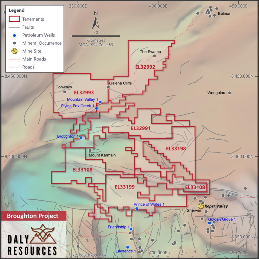
– 13 granted contiguous tenements for 3,713 km2
– Largest landholder in the district
– Bounding ground held by Glencore/Teck
Project logistics
– Pastoral land – simple access
– Bitumen highway and numerous gravel roads
– Nearby port where McArthur ore is exported
– Gas pipeline
– Close to emerging Gas province (Beetaloo)
Conceptual overview
– Fault-controlled sub-basin created by growth faulting
– Rapid subsidence and deposition of euxinic shales with high TOC and pyrite
– Sub-seafloor exhalation or early diagenetic replacement (SEDEX)
– Sub-basins are deep, spatially restricted and characterized by rapid thickness changes in host facies (0>1000m over 1-2 km).
Advanced “Hot Spring” target
Abutting interpreted growth fault on western trough margin
Shallow AEM conductor and surface synclines mimicking underlying sub-basin shape at
>500m depth (no hist drilling)
Work plan
Ground gravity to refine target
Deep diamond drilling to test for Tier 1 SEDEX footprint
1x2km at Hot Spring
Regional gravity interpretation and geophysics infill
Broughton Project
McArthur Basin
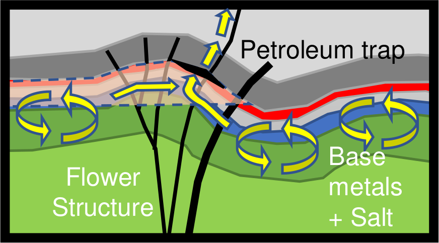
Petroleum system model
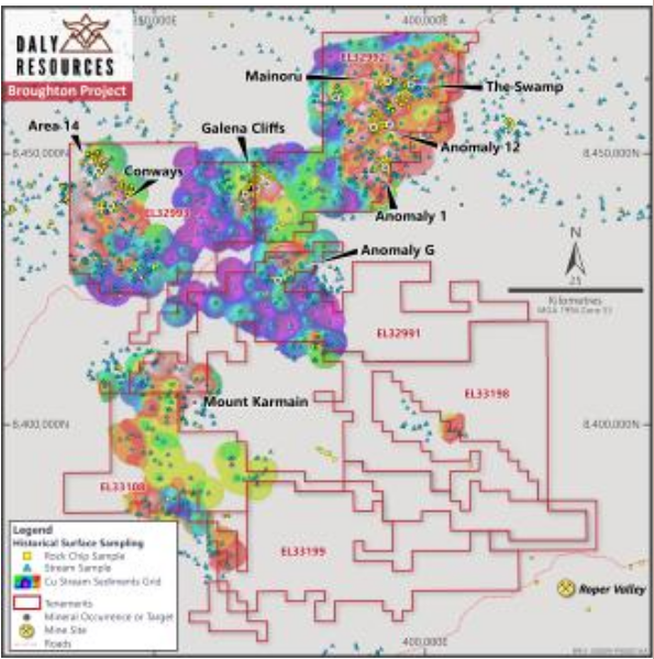
Cu stream sediment anomalism
Tier 1 discovery potential at surface in emerging northern McArthur Basin
Target commodity & analogue
Copper & Zinc – stratiform sediment-hosted Cu-Zn
Dzhezkazgan, Kazakhstan (477Mt @ 0.94% Cu & 13g/t Ag)
Century Zinc Deposit (118Mt @ 12% Zn+Pb)
Overview
– Applying novel petroleum systems approach to minerals exploration
– Project generated via review of historic petroleum wells and seismic
– Has all the right ingredients for a Tier 1 sediment-hosted district
– Largely unexplored with only 50% coverage by stream sediment sampling and only 11 drillholes >50m deep
– Broadly distributed target units at surface – potential to make discovery through simple surface exploration
Project tenure
– 6 granted tenements for 4,954 km2
– First mover advantage over prospective structures and fertile hosts
Project logistics
– Pastoral land – simple access
– Commercial accommodation and numerous gravel roads
– Close to emerging Gas province (Beetaloo)
Conceptual overview
Large flower structures and roll-over anticlines throughout project along major strike-slip faults (with relict oil columns)
Extensive base metal source in clastics & mafic/felsic volcanics
Widespread evaporites to generate saline super-brine
Interplay between super-brine and oil/gas traps (cf Century)
Historic “smoke”
Widespread base metal anomalism in surface Geochem (largely undrilled)
% level rockchip and petroleum well anomalies
Work plan
Airborne EM to map structure and define trap targets
Regional stream sediments & soils to infill gaps and follow up historic anomalous zones
Regional structural interpretation and geophysics infill
Huckitta Project
Georgina Basin
Sandfire Project, generated from first principles to discover Tier 1 stratiform Cu
Target commodity & analogue
Copper – stratiform sediment-hosted Cu
Central African Copper Belt, DRC/Zambia (3.3 Gt @ 2.68% Cu)
Kupferschiefer, Germany/Poland (3.6 Gt @ 1.99% Cu, 57 g/t Ag)
Overview
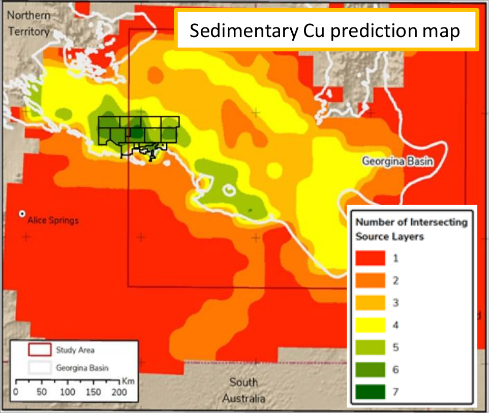
Project generated from first principles by basin-specialist GeTeck
Group, who reviewed the prospectivity of the entire Georgina Basin
for Sedimentary Copper
Ground applied for over area with all seven selection criteria
overlapping – Has all the right ingredients for a Tier 1 sediment-
hosted district
Largely unexplored with almost no baseline geochemical data, coarse
regional geophysics and only 20 drillholes >50m deep
Project tenure
12 granted tenements for 7,477 km2
First mover advantage over prospective structures and fertile hosts
Project logistics
– Pastoral land – simple access
– Largely sealed Plenty Highway along southern margin
– Nearby historic Molyhil mine and Jervois polymetal project in feasibility
– Shielded from northern wet season, providing year-round accessibility
Conceptual overview
Regional sed-Cu targeting criteria: Lithospheric thickness, redbeds, mafic
volcanics, evaporites, traps, juxtaposition of source/brines, basin thickness, heat flow
Based on Hitzman et al (2010) model for sediment-hosted stratiform copper
Metals sourced from redbeds, liberated by a basin brine derived from the breakdown of evaporites
Trapped along redox boundary at lowermost basin seal (carbonaceous shale)
Important observations
Like the analogous Copper Belt, the rift depocentre has been buried to significant
depths driving the mineral system (Irindina Complex)
Excellent TOC-rich host rock that extends across the entire project (Arthur Ck Fmn)
Work plan
Airborne EM to map distribution of organic facies (cu host) and structures that enable cross-stratal fluid flow
Regional stream sediments and soils to identify anomalous zones
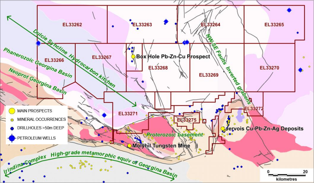
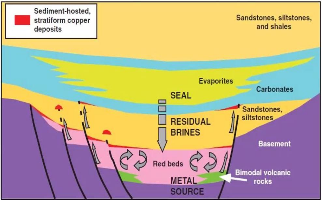
Hitzman et al 2010 model – all components present
